GUEST POST
From Field Trip to Top Grades: Using Iceland to Bring Geography to Life
Ed is a Geography tutor with a University of Bristol BSc who specialises in Natural Hazards and glacial monitoring from studying abroad in Reykjavík, and has 400+ hours of GCSE Geography and A-Level Geography tutoring. The article shows how first-hand experiences in Iceland can turn abstract topics into case studies and stronger exam answers, with practical tips that work anywhere.
From Field Trip to Top Grades: Using Iceland to Bring Geography to Life
By Ed C | GCSE and A-Level Geography Tutor | Sherpa Tutor
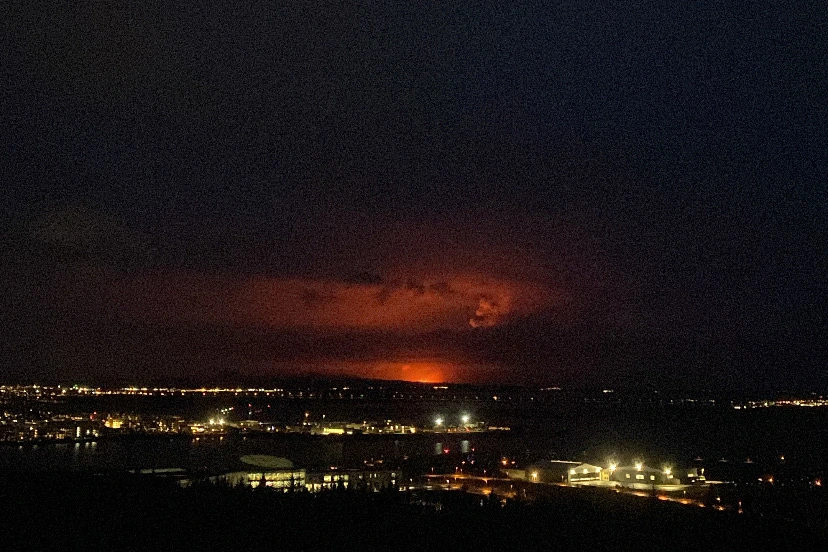
The Sundhnúkur crater row eruption near Grindavík, seen from Reykjavík at 20:36 on 16 March 2024, 13 minutes after it began - the fourth of nine eruptions between 2023 and 2025. (Photo: Ed Cousins).
Every Geography student learns that Iceland sits on one of the most active constructive plate boundaries in the world. Far fewer, however, have stood with one foot either side of a rift valley, felt the ground steam beneath them, or watched meltwater pour off a retreating glacier. When I studied in Reykjavík as part of my Geography degree, I saw the gap between those two kinds of knowledge very clearly. One is a fact that you must memorise. The other becomes part of how you think.
Ofsted, in their 2023 Geography report, found that fieldwork is mostly "underdeveloped" in schools, with the majority of students not moving beyond the exam boards' requirements. The 2026 AQA GCSE Geography Examiner Reports found that the crucial issue is the use of generic examples that lack detailed explanations.
This blog is for parents and teachers who want to nurture and grow a student’s love of Geography beyond the syllabus. Iceland is my example, but the method works anywhere, be it on summer holidays, school trips, or a weekend visit to somewhere new in the UK.
Why You Need to See It First-Hand
Geography is the study of real places, real processes, and real people, yet in the classroom it is learnt primarily through diagrams, textbook chapters, and long presentations. This method works to a point, and don’t get me wrong, it is necessary for building a knowledge base. But concepts like plate movement, glacial erosion, or energy security stay abstract until a student has something concrete to attach them to.
A first-hand experience gives students three things a textbook can’t:
Memory hooks. A place you’ve visited is far easier to recall under exam pressure than a case study you’ve read about.
Scale and context. Seeing how big a glacier is, or how close a town sits to a volcano, makes impacts and responses feel real.
Ownership. Students who have seen something for themselves tend to ask better questions and remain curious about new ideas.
Iceland: A Living Classroom
Few places are capable of packing so much Geography into such a small area. In one trip you can see:
Deep canyons. Rivers cut deep, steep-sided gorges through layers of volcanic rock. Glymur is Iceland’s second-tallest waterfall, standing at 198 metres. Exam link: river landscapes, waterfalls, and gorge formation.
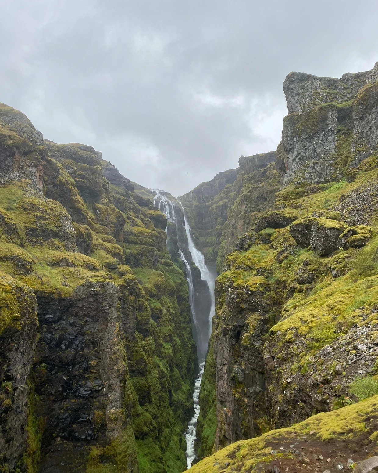
Glymur, Hvalfjörður (Photo: Ed Cousins).
Glaciers and glacial landforms. Valley glaciers can extend for many miles, with large frozen proglacial lakes at their base. Skaftafellsjökull flows from Vatnajökull in south-east Iceland, often described as the largest glacier in Europe, which covers roughly 8% of Iceland’s land area. Black bands of volcanic ash are present in the ice at Sólheimajökull, where Icelandic students measured that the glacier has retreated by 408 metres between 2010 and 2021. Exam link: glacial landforms and glacial retreat, impacts of climate change.
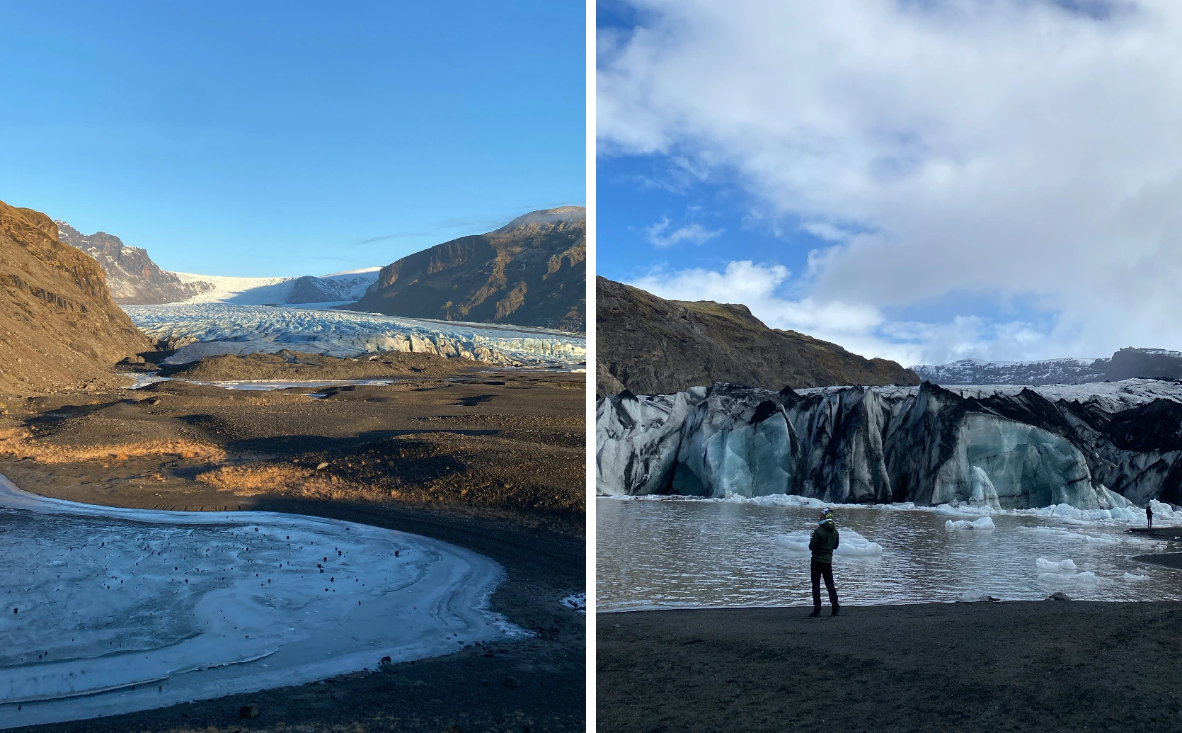
Skaftafellsjökull in Vatnajökull National Park (left), Sólheimajökull (right) (Photo: Ed Cousins).
Waterfalls. The hollow opening behind the waterfall shows how water, spray, and a deep plunge pool can erode the rock at the base of the cliff. Seljalandsfoss is 62 metres high and sits on the Seljalandsá River, with a top layer of hard lava and much softer rock beneath. Exam link: waterfall formation (undercutting).
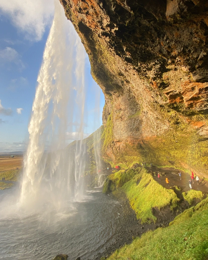
Seljalandsfoss (Photo: Ed Cousins).
Coastal landforms. Layered basalt sea cliffs with a boulder-strewn shore at the base, where waves erode coastal material. Látrabjarg is located at the westernmost point of Iceland and is often described as the westernmost point of Europe. It also contains a great diversity of seabirds and is home to its most famous resident, the puffin. Exam link: coastal erosion and cliff formation.
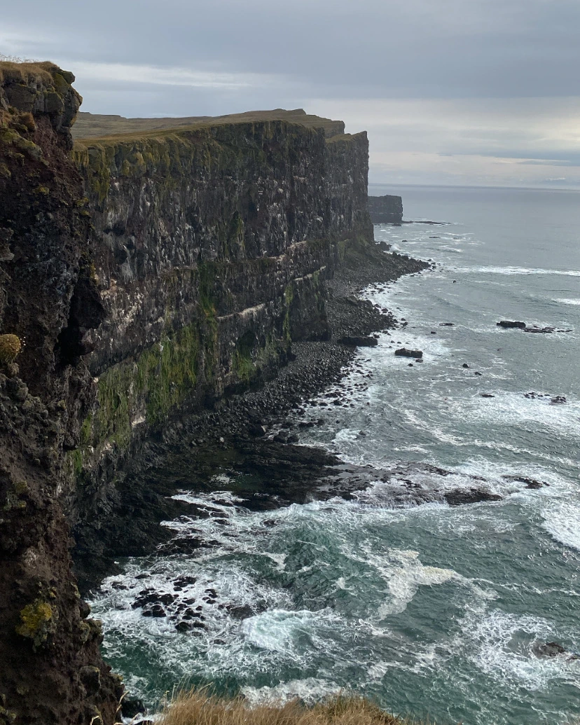
Látrabjarg, Westfjords (Photo: Ed Cousins).
Rural settlements. Flatey is a tiny island roughly 2 km long and 0.5 km wide. Once one of Iceland’s main cultural centres, Flatey now has only a handful of permanent residents, and many neighbouring islands, inhabited until a few decades ago, stand empty. Fish drying in the wind is a reminder of how island life has always depended on the sea’s resources. Exam link: rural depopulation and natural resources.
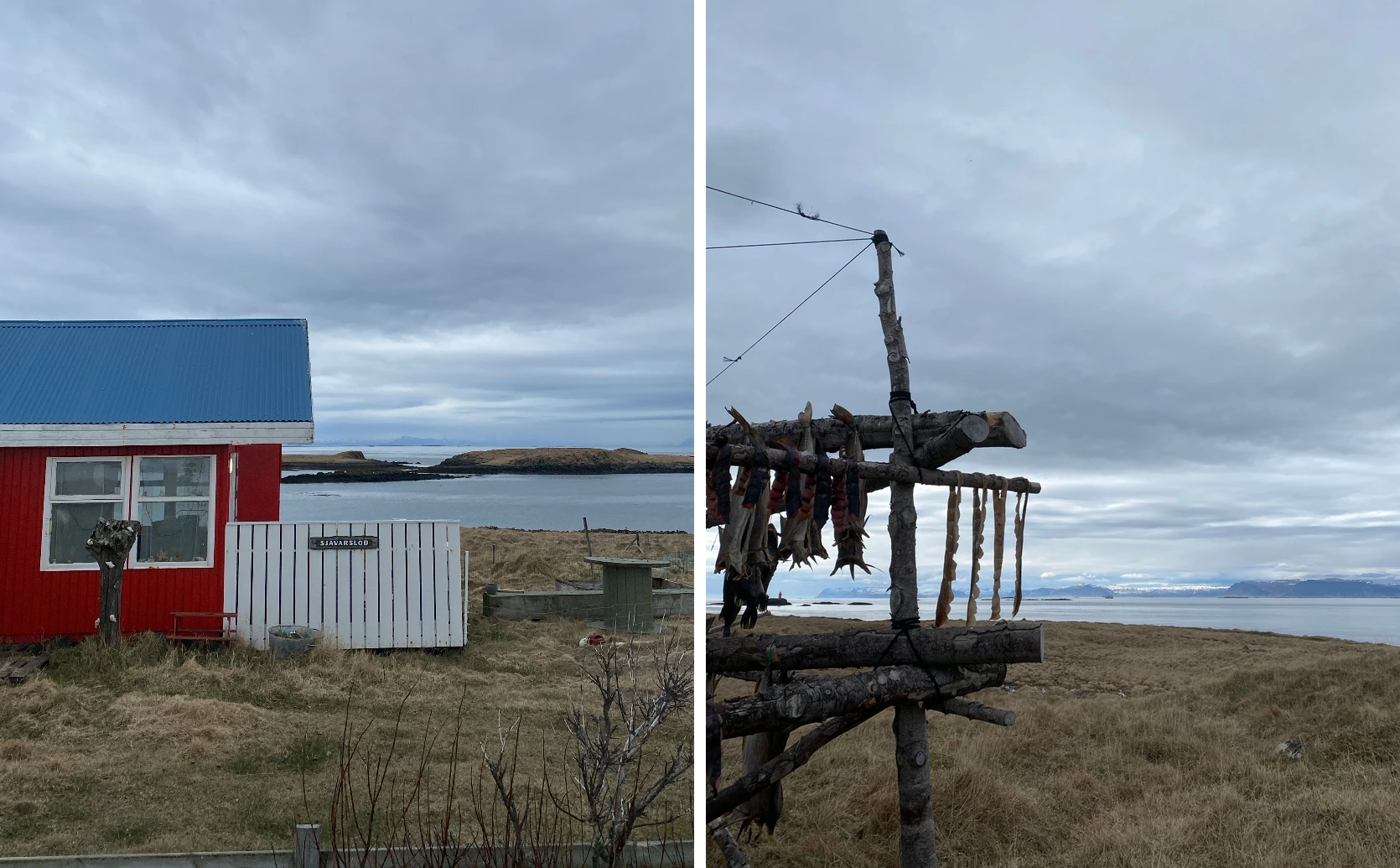
Flatey, Breiðafjörður (Photo: Ed Cousins).
Turning Experience Into Exam Marks
As a tutor, I have seen first-hand what holds back students in lessons. It is confusion over which case study to use, being vague with specific details, and leaving out vital information.
Importantly, you don’t need to be a geographer to help a young person think like one. A few simple habits can make any trip more valuable:
Ask “why is it like this?” At each stop, ask your child to explain one thing they can see. “Why is this cliff so steep?” “Why does this town sit where it does?”
Take photos with a purpose. Aim for one photo that shows a process (waves hitting a cliff) and one that shows an impact (houses at risk of flooding).
Connect it back to school. Find a topic in the specification or textbook and write the place down as a case study, then support this with one or two additional facts.
All of this has a payoff in the exam hall. Examiners consistently reward answers that use confident, specific, well-understood examples rather than generic ones. A student who has stood on the edge of a tectonic plate remembers the detail, and detail is what moves an answer up the mark scheme.
The key is helping students move from “I saw it” to “I can use it”. Doing this is simpler than it seems and can be prompted by asking students after a trip to tell you about:
1. The process at work (e.g., glacial retreat).
2. The evidence they saw.
3. The exam topic it links to.
If they can answer these three points, they can employ this skill in their exam and show off their real-world, lived geographical experiences!
To help see how this looks in practice, take a typical question: “Using an example, explain how people respond to volcanic hazards.”
A generic answer: “People are evacuated and the government builds defences to protect homes, such as in Iceland.”
A specific answer: “Responding to volcanic hazards can include evacuating local residents and building defences to protect homes. For example, the town of Grindavík in Iceland, which has a population of roughly 3,500, was evacuated on 10 November 2023 because magma moving beneath the town caused intense earthquakes. In addition, earth barriers were built to divert lava away from the town and the nearby Svartsengi power station.”
You Don't Need to Go to Iceland
Iceland is a spectacular example, but the approach works anywhere. A day on the Jurassic Coast covers coastal erosion and landforms. A walk in the Lake District or Snowdonia shows glacial landforms. A city break can become a study area of urban regeneration, transport systems, and inequalities.
What matters most is the habit: noticing, asking why, and linking what you see back to what you learn.
Helping your child improve their Geography grade can be made simple with this method, and students who can bring examples into their answers are far better placed to pick up marks.
Parents
Students

Ed C
Tutor
GCSE, A-Level & IB Geography: exam technique that moves grades.


Looking for a tutor?
Sherpa has hundreds of qualified and experienced UK tutors who are ready to help you achieve your goals. Search through our tutors and arrange a free 20 minute introduction through our industry-leading online classroom.
Find a TutorSimilar Articles
10 of the Best Educational Podcasts and Audiobooks
The bandwidth of human knowledge has increased tenfold since the invention of television. You can absorb knowledge with any combination of educational audio content available online.
James Gurnett
26th October